ABOVE: The latest forecast update from Severe Weather Center 9. To stay on top of changing weather conditions, be sure to download our free WSOC-TV weather app.
The death toll from Hurricane Helene has reached at least 40 across four states, The Associated Press reported.
Helene has left an enormous path of destruction across Florida and the entire southeastern U.S. The Category 4 hurricane made landfall Thursday in Florida, snapping trees like twigs, tearing apart homes and sending rescue crews on desperate and dangerous missions to save people from floodwaters. The damage extended hundreds of miles to the north, with flooding as far away as North Carolina.
Click here for the latest local flood alerts.
According to an Associated Press tally Friday, the deaths occurred in Florida, Georgia, North Carolina and South Carolina.
South Carolina’s Department of Public Safety confirmed 19 total deaths, including five in Spartanburg, and four in Greenville.
North Carolina officials previously reported two deaths -- one in Charlotte and another in Catawba County.
Western North Carolina was hit especially hard.
UPDATES
10 p.m. Latest forecast with Chief Meteorologist John Ahrens

8:10 p.m.
7 p.m. - PHOTOS: Chopper 9 Skyzoom over Lake Lure, Chimney Rock
1 of 27


6:30 p.m. - New video: Cowans Ford Dam
From Chopper 9: The flood gates at Cowans Ford Dam are open. Officials are warning Mountain Island Lake will quickly rise @wsoctv pic.twitter.com/4zP2BRv9qy
— Joe Bruno (@JoeBrunoWSOC9) September 27, 2024
5:35 p.m. - The flood gates at Cowans Ford Dam are open. Expect Mountain Island Lake to quickly rise. Use extreme caution. A shelter is open at Tuckaseegee Rec Center at 4820 Tuckaseegee Rd, Charlotte, NC. Call 911 only in emergencies. Click here for updates.
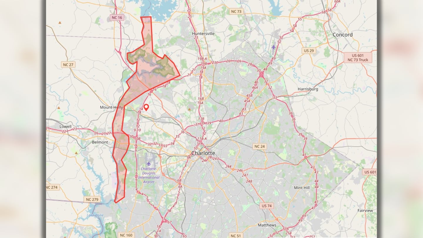
4:25 p.m. - Charlotte Mecklenburg Emergency Management has been informed by Duke Energy that flooding is imminent at Mountain Island Lake starting late this afternoon/evening due to several days of excessive rainfall. Residents on Lake Wylie will also see rising water levels and should maintain heightened awareness.
Duke Energy will be moving large amounts of water through the Catawba River System including Lake Norman, Mountain Island Lake and Lake Wylie. This will affect portions of the Catawba River within Mecklenburg County. Flood waters will rise rapidly and conditions will change quickly.
Lake level information is available on the Duke Energy website, by calling 800-829-5253, and via the Duke Energy Lake View mobile app.
All residents near the shoreline along the lakes and rivers are encouraged to take caution. Those in need of special assistance should assess their risk and take necessary precautions.
A general shelter is set up for displaced residents at Tuckaseegee Rec Center, located at 4820 Tuckaseegee Road. Visit cltgov.me/helene for evacuation tips.
Residents in immediate danger should call 911.
4:20 p.m. - Charlotte Fire responded to 559 emergency calls. 280 were directly related to the storm’s effects, including flooding, downed power lines, and storm damage.
4 p.m. - Alexander County and the town of Taylorsville have issued a voluntary curfew from 7 p.m. Friday until 8 a.m. Saturday. It is highly recommended that citizens stay off the roads during this time due to downed power lines and other debris in the roadways. Alexander County Emergency Services and Taylorsville personnel have responded to more than 600 calls on Friday. The curfew will allow emergency crews to rest and replenish emergency supplies.
3:40 p.m. - Friday afternoon weather update: “The worst is over, friends, but you will still want to keep that rain gear around,” said Chief Meteorologist John Ahrens said Friday afternoon.
There will be a few spotty showers this weekend with the best rain chance on Sunday.
It certainly will not be as bad as what we just went through and won’t last that long, Ahrens said. It will feel muggy out there so it is still going to be a while before you feel real fall weather.
3:30 p.m. - There are voluntary evacuations for the Nivens Cove neighborhood along Mountain Island Lake, Gaston County officials said.
Emergency management in Gaston County said they are moving its emergency shelter from the Citizens Resource Center in Dallas to Belmont Middle School, 1020 South Point Road, in Belmont.
3 p.m. - People along the Catawba River are being told Friday afternoon to get ready to evacuate.
Duke Energy needs to move a large amount of water through the Catawba River system as water levels continue to rise.
The area stretches from the southern part of Lake Norman through Mountain Island Lake and down to Lake Wylie.
Channel 9 has asked emergency management how many homes are in this evacuation zone.
There is a shelter at the Tuckaseegee Recreation Center on Tuckaseegee Road.
11 a.m. - Officials say the failure of a dam in a western North Carolina town is “imminent.” Anyone below the Lake Lure Dam is asked to evacuate to higher ground as quickly as possible.
North Carolina Gov. Roy Cooper confirmed two fatalities tied to the storm.
10:30 a.m. - Tropical Storm Helene is moving north and the Charlotte area has seen the last of the heavy downpours as of 10:30 a.m., but western counties will likely be dealing with rain for a few more hours.
Rivers and creeks are overflowing, and Channel 9 crews have spotted flooding on roads like Interstate 40 and Highway 70 near Black Mountain.
Happening now on Highway 70 in Black Mountain, truck drivers are stuck in a warehouse lot while floodwaters rise, threatening to carry them away. Two of the 7 trucks have tipped already.@wsoctv @TelemundoCLT #ncwx pic.twitter.com/PLJVKfz6YA
— Jorge Vélez 💻 (@jorgeveleztv) September 27, 2024
9 a.m. - North Carolina counties in the west and northern parts of the state are seeing big impacts from flooding in cities. Channel 9 spotted streets underwater in Asheville and Boone, and flash flood warnings are in place for the rest of the day as the rain works through our waterways.
At this point, hundreds of thousands of customers in North Carolina are without power, according to Duke Energy. Many traffic lights are also without power due to the impact of Tropical Storm Helene. Keep updated on active weather alerts at this link.
FRIDAY MORNING STORIES FROM HELENE:
- 1 dead in Charlotte after tree falls on home as Tropical Storm Helene moves through the area
- Multiple rescued from flooding Friday morning as Helene barrels toward Carolinas
- Western North Carolina sees heavy flooding from Helene
- 2 trapped after tree falls on home near creek in Rock Hill
- School districts adjust schedules ahead of Helene
8 a.m. - A tornado watch was reissued for most of North Carolina and parts of South Carolina until 6 p.m., according to the National Weather Service.
No tornados have been reported as of 8 a.m. Friday, but Severe Weather Center 9 is keeping an eye out for any spin-ups.
7 a.m. - Emergency crews have seen an uptick in the number of trees falling due to severe weather in the area. One person has already died from a tree falling on a home, and Channel 9 crews are looking into additional reports across the Charlotte area and South Carolina.
Public Safety Alert: Severe Storm Damage: High winds from the recent storm have caused significant damage across our area. Charlotte Fire is actively responding to multiple incidents involving downed trees and power lines.
— Charlotte Fire Dept (@CharlotteFD) September 27, 2024
For your safety, please keep the following in mind:… pic.twitter.com/TCnOonO7am
More than 50,000 people in the Charlotte area were without power as of 7 a.m., according to Duke Energy.
6:15 a.m. - At least one person is now dead in Charlotte as tropical weather moves into the area. This marks four people that have died amid Tropical Storm Helene.
MEDIC confirmed to Channel 9 that one person was killed when a tree fell onto a home on Brookway Drive in northwest Charlotte. Another victim was hurt and taken to the hospital.
The deluge of rain has saturated the ground and high wind gusts are putting trees at risk of falling over. Stay prepared and avoid top-level rooms throughout the severe weather.
6 a.m. - A flash flood warning was extended to 11 a.m. for Mecklenburg, Cabarrus and Union counties, and many other local counties are still under flash flood warnings. Heavy rain and strong winds will continue through the early morning.
More power lines are being affected by the weather, and the number of power outages is continuing to climb Friday morning. According to Duke Energy, nearly 30,000 customers were without power as of 6 a.m.
By 8 am, most of the area will have more heavy rain and strong winds. Another few inches likely in the metro, several inches likely farther west. Things will then improve after 9 am. Stay in this morning if you can and keep an eye on those creeks, they will rise rapidly. pic.twitter.com/pTp4YwQKJ7
— Keith Monday (@kmondayWSOC9) September 27, 2024
(See photos of the impacts)
1 of 45


5:30 a.m. - The wind from Tropical Storm Helene is starting to affect the Charlotte area. Gusts are reaching more than 40 miles per hour, and they could peak near 70 mph in areas near the mountains.
Rain will continue through the morning, and flash flood warnings are in place in several counties until at least 9 a.m. Friday.
The bigger wind from Helene is here NOW. Winds are gusting over 40 mph and could jump to over 50 mph through the morning. This will lead to more trees down and power outages. pic.twitter.com/Y56TDRlZCm
— Keith Monday (@kmondayWSOC9) September 27, 2024
According to Duke Energy, there were about 14,000 people without power early Friday morning. That number is expected to increase as the wind affects power lines.
4:55 a.m. - Helene has been officially downgraded from a hurricane to a tropical storm, according to the National Weather Service. Rain is continuing to accumulate in the Carolinas as the storm moves across Georgia.
3:30 a.m. - Helene has made landfall and continues to move through Georgia Friday morning. Heavier rain and stronger winds will arrive in the Carolinas around 5 to 6 a.m.
A tornado watch is in effect until 8 a.m. Friday for the following counties: Anson, Cabarrus, Gaston, Mecklenburg, and Union counties. There are flash flood warnings in place early Friday morning in Chester, York, Avery, Burke, Caldwell and Iredell counties.
Just before 4 a.m., a National Guard rescue truck ended up getting stuck in high water near Riverside Drive in northwest Charlotte.
HEADS UP: Roads are quickly flooding in the Carolinas - even a National Guard truck got stuck in high water in west Charlotte Friday morning.
— WSOCTV (@wsoctv) September 27, 2024
If you can't see the street, don't drive through it.
STAY UPDATED > https://t.co/Al2K1qcqYQ pic.twitter.com/VflllIT1DX
There is a tropical storm warning for parts of our area. The storm has prompted flash flooding alerts throughout the day and will continue.
Winds may gust over 50 miles per hour in the city, with higher gusts near 70 miles per hour in the mountains. That could bring trees down onto roadways and homes.
Keep an eye on traffic conditions with Channel 9′s live traffic map at this link.
>>Click here for the latest alerts
FRIDAY FORECAST:
- Temperatures are expected to only warm to the mid to upper 70s thanks to the rain. The worst weather comes from midnight through about 10 a.m. Friday.
- Rounds of very heavy rain and strong winds will lead to more flooding and trees down, especially west in the mountains. However, we are only expecting between 5 to 7 inches in the metro, but amounts in the high country could exceed 1 foot.
- Catastrophic flooding with landslides is possible where the heaviest rains fall. Right now, that risk looks highest in western North Carolina, just outside of our area.
- However, there could be similar issues in the northern mountains as well. Winds will also pick up with gusts over 40 mph in the metro and over 50 mph in the mountains. This could lead to trees down and power outages.
- We’ll also be on the lookout for any brief spin-ups with a low tornado risk.
- Helene will accelerate to the northwest by mid to late morning Friday, and our weather will improve quickly. River flooding will continue to be an issue going into the weekend.
Helene is close to being a category 2 storm with winds of 90 mph. It is still forecast to become a major hurricane later this afternoon and could be a category 4 by landfall this evening. Our weather continues to go downhill late tonight through early Friday morning. Stay alert! pic.twitter.com/0F7ffME0Fr
— Keith Monday (@kmondayWSOC9) September 26, 2024
>> Channel 9′s Weather 24/7 stream has the latest local weather all day, every day. Watch wherever you stream — on our website, or through your mobile app or smart TV.
WEATHER RESOURCES:
- WSOC Weather 24/7
- Interactive Radar
- Download our weather app for Severe Weather Alerts
- Hour-by-Hour Forecast
- 7-Day Forecast
FOLLOW OUR TEAM ON TWITTER:
- Chief Meteorologist John Ahrens
- Meteorologist Keith Monday
- Meteorologist Madi Baggett
- Meteorologist Joe Puma
©2024 Cox Media Group