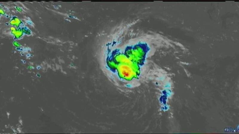
MIAMI — A rapidly strengthening Hurricane Florence churned across the Atlantic on Sunday toward a possible direct hit on the U.S. Southeast late this week, triggering warnings to people up and down the coast to get their emergency kits ready, map out escape routes and fill sandbags.
Red flags flying on beaches warned swimmers to stay out of waters already roiled by the distant storm, and cruise ships and Navy vessels were set to be steered out of harm's way. People rushed to buy bottled water, plywood and other supplies.
Florence crossed the 74 mph threshold from tropical storm to hurricane Sunday morning, and by 11 p.m., its winds were up to 90 mph as the National Hurricane Center warned it was expected to become an extremely dangerous major hurricane by Monday and remain that way for days.
Forecasters say the storm will become a major hurricane by Monday and be an extremely dangerous hurricane by Wednesday with winds of 150 mph
It is projected to approach the Carolina coastline Thursday into Friday.
The storm may likely linger nearby all weekend after that.
The storm's sustained winds reached 90 mph, just over the threshold for a hurricane, as it made its way across the Atlantic, about 750 miles southeast of Bermuda, the National Hurricane Center said. It was moving west at 7 mph.
The current track has Florence making landfall near Wilmington Thursday afternoon and evening and turning to a very strong tropical storm on Friday.
The University of North Carolina at Wilmington is encouraging its students to leave campus this week for a safer location.
The university said Sunday that it has issued a voluntary evacuation for students starting at noon on Monday. That means students are urged but not required to leave and classes are canceled.
The National Hurricane Center says it is still too early to predict the hurricane's exact path, but a huge coastal area from northern Florida to North Carolina has been urged to remain on guard for the possibility of a major hit later in the week.
A statement from the university says officials will continue monitoring the forecast and that additional actions required may include a mandatory evacuation or campus closure.
Based on the most recent track, the Carolinas coast will get hurricane-force winds, major storm surge, widespread flooding.
Highest impact areas will be Myrtle Beach northward to Outer Banks.
The Charlotte area will get tropical storm-force winds, bands of very heavy rain and flooding threats, especially for our eastern counties.
Channel 9 spoke with a Lowe’s manager near Northlake Mall who said the biggest demand so far is generators.
The manager also said the store has other supplies you might need, including gas cans, batteries and bottles of water.
Lowe's emergency control center experts are closely watching the storms to see what areas may be hit hardest and what supplies they might need.
“In my career with the company, it seems that they mostly react,” Lowe’s manager Jennifer Melvin said. “They're watching the weather, but not until we get the confirmation that the storm is coming that they will rush into stores and buy what we have left."
Officials say the effects of Hurricane Florence are already being felt along the North Carolina coast.
The National Weather Service in Morehead City said swells from the storm will lead to dangerous rip currents in certain coastal areas Sunday. Beachgoers were recommended to stay out of the water.
On the Outer Banks, the town of Nags Head said it had posted no-swimming flags on beaches. The Cape Hatteras National Seashore also urged people to stay out of the ocean.
North Carolina remains under a state of emergency issued by Gov. Roy Cooper.
The Miami-based center said that it was still too early to predict the hurricane's exact path but that a huge coastal area from South Carolina to the mid-Atlantic region should prepare for a major strike late in the week.
"All indications are that Florence will be an extremely dangerous Category 4 hurricane while it moves over the western Atlantic toward the southeastern United States," the hurricane center said. A Category 4 storm packs winds of 130 mph (209 kph) or more and has the potential for catastrophic damage.
The NHC said there is an increasing risk for two life-threatening impacts from Florence -- storm surge at the coast and freshwater flooding from prolonged heavy rainfall inland.
Channel 9 will have continuing coverage of Hurricane Florence and its potential impacts along the Carolina coast. To receive the latest hurricane alerts, download the WSOCTV news app and tap the blue "Hurricanes" tag.
The Miami-based weather center said it is too soon to tell the exact timing, location, and how strong the impact will be, but it recommends the coast and inland areas from South Carolina to the mid-Atlantic region should monitor Florence's progress.
Officials said those in the western Carolinas and in northeast Georgia should closely monitor the track of Florence as some impact will be possible late this week, perhaps Thursday or Friday.
Moments after Florence regained hurricane status, North Carolina Gov. Roy Cooper issued a statement urging all North Carolina residents, businesses, and visitors to prepare for possible impacts.
"Everyone in North Carolina needs to keep a close eye on Florence and take steps now to get ready for impacts later this week. State emergency management, transportation, health experts and others are making sure North Carolina is prepared for the storm, and I urge the public to review your emergency plans and gather your supplies now."
Cooper also warned of inland damages such as river flooding and power outages as seen during Hurricane Matthew in 2016.
"Experience has shown us that storms and heavy wind and rain can affect the entire state, so we must all be alert and ready," Cooper said.
To read Gov. Roy Cooper's statement and how North Carolina is preparing for the storm, click here.
Florence could cause dangerous surf and rip currents along parts of the U.S. East Coast from Florida to North Carolina this weekend as the storm swirls across the Atlantic, according to forecasters at the National Hurricane Center.
>> Watch the video above for Severe Weather Center 9's latest forecast update on Hurricane Florence.
[Q&A: With severe storms approaching US, what to expect?]
The storm is forecasted to become a "major hurricane" Monday, travel between Bermuda and the Bahamas on Tuesday and Wednesday before approaching the southeastern U.S. coast on Thursday, the Miami-based weather center said.
Forecasters say the storm is expected to become a "major hurricane" early this week and is predicted to approach the southeast U.S. coast by Thursday.
Track the storm and its latest forecast by downloading our weather app.
In South Carolina, Gov. Henry McMaster declared a state of emergency Saturday to give his state time to prepare for the possible arrival of a hurricane. McMaster emphasized that there's no way to know yet when and where the storm will hit land, or when evacuations might be called.
"This storm is too powerful and its path is too uncertain to take any chances," McMaster said. "We are mobilizing the state's resources to make sure we are prepared, and the people of South Carolina must not hesitate to prepare for the possibility of a hurricane impacting our coast."
"If you experienced Hurricane Irma last year, Hurricane Matthew in 2016, or even the flood in 2015: think about all the supplies you didn't have or safety measures you didn't have time to implement," SCEMD director Kim Stenson said. "Now is the time to make sure you have everything you may need: check your emergency supplies, prepare your home and your property, and have a plan for where you will go if the worst-case scenario becomes reality."
Read the full statement here.
[Tropical Storm Gordon: Child dead after tree limb falls on mobile home, officials say]
"The risk of other direct impacts associated with Florence along the U.S. East Coast next week has increased. However, there is still very large uncertainty in model forecasts of Florence's track beyond day (five), making it too soon to determine the exact location, magnitude, and timing of these impacts," hurricane specialist Robbie Berg wrote in a forecast advisory.
On Friday, North Carolina Gov. Roy Cooper declared a state of emergency and urged residents to use the weekend to prepare for the possibility of a natural disaster.
“While it’s still too early to know the storm’s path, we know we have to be prepared,” Gov. Cooper said. “During harvest, time is of the essence. Action today can avoid losses due to Florence.”
Read the full statement here.
Improving atmospheric conditions were expected to allow Florence to regain its former strength. The storm reached major hurricane status last Wednesday, peaking with maximum sustained winds of 130 mph (210 kph).
[Family emergency supply kit must-haves]
The U.S. Navy is making preparations this weekend for its ships in the Hampton Roads area to leave port as Florence approaches the East Coast.
The U.S. Fleet Forces Command said in a news release Saturday that the ships will get ready in anticipation of getting underway Monday to avoid storm damage.
Adm. Christopher Grady said in a statement that the decision was based on Florence's current track, which indicates the area could see strong sustained winds and storm surges.
Swells generated by Florence are affecting Bermuda and starting to reach parts of the Eastern Seaboard, the National Weather Service said.
Meanwhile, two low-pressure systems off the coast of Africa behind Florence also had high chances of developing into tropical storms, forecasters said.
"Since we are near the peak of hurricane season, this is a good time for everyone who lives in a hurricane-prone area to ensure they have their hurricane plan in place," hurricane specialist David Zelinsky wrote in a forecast advisory.
[15 safety tips that could save your life during a hurricane]
Read more top trending stories on wsoctv.com:
- TRACKING: Florence expected to rapidly intensify to hurricane strength Sunday
- 3 suspects charged after mayor, wife of NC town found dead at home
- Police: Argument inside west Charlotte convenience store led to shooting
- WATCH: Jaclyn Shearer's Sunday forecast outlook
- 8 arrested in protest over toppled Confederate statue 'Silent Sam'
Associated Press


