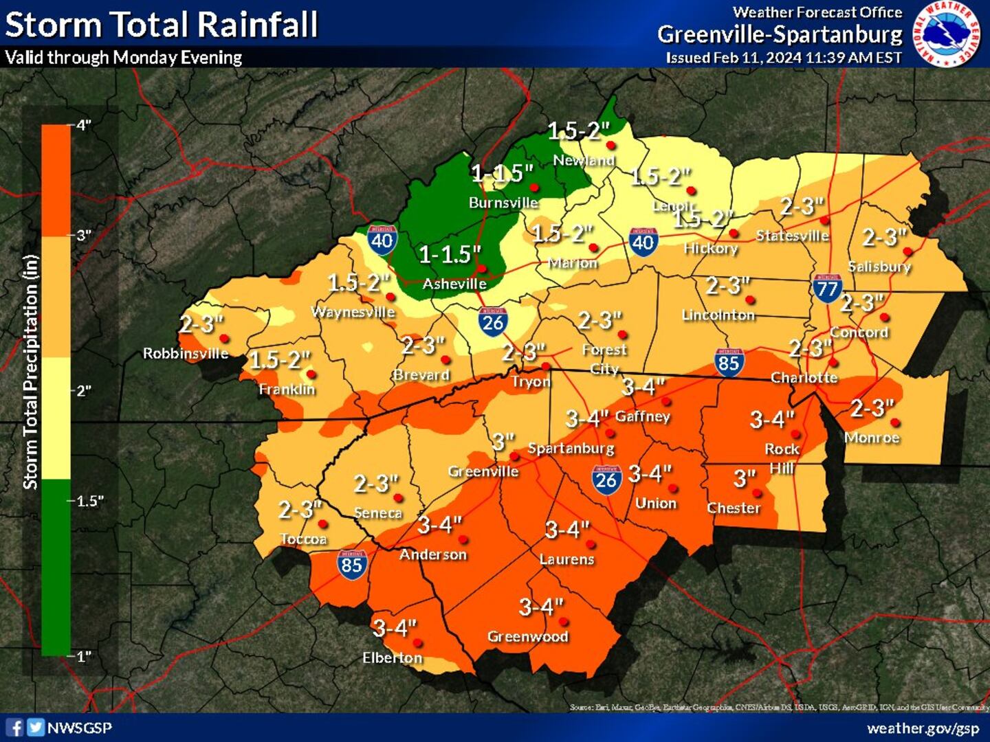
CHARLOTTE — Ahead of heavy incoming rainfall, the National Weather Service issued a Flood Watch for many counties in Channel 9′s viewing area.
Mecklenburg, Union, Gaston, Cabarrus, Lincoln, and Cleveland counties are under a Flood Watch starting at 10 p.m. on Sunday.
In South Carolina, Chester and York counties are also under watch.
NWS expects widespread rain amounting between two to four inches.
EXCESSIVE RAINFALL. Some increasing concern for localized flooding in Carolinas Monday/Monday night. Purple/Red = 2-4” rain. Weather team @wsoctv watching closely. @JoePumaWSOC9, @kmondayWSOC9, @JohnAhrensWSOC9, @madithemet, @SUdelsonWSOC9 pic.twitter.com/d5ZQNEECbK
— Wayne Mahar (@WayneStormWatch) February 11, 2024
Certain areas could see higher amounts locally.
>>> Stay up-to-date with Channel 9′s Severe Weather Center resources:
- WSOC Weather 24/7
- Interactive Radar
- Download our weather app for Severe Weather Alerts
- Hour-by-Hour Forecast
- 7-Day Forecast
The Flood Watch will continue through Monday evening.
See the full statement below:
* WHAT...Flooding caused by excessive rainfall is possible. * WHERE...Portions of northeast Georgia, including the following areas, Elbert, Franklin, Habersham, Hart, Rabun and Stephens, North Carolina, including the following areas, Cabarrus, Cleveland, Eastern Polk, Gaston, Graham, Greater Rutherford, Haywood, Henderson, Lincoln, Macon, Mecklenburg, Northern Jackson, Polk Mountains, Rutherford Mountains, Southern Jackson, Swain, Transylvania and Union NC, and upstate South Carolina, including the following areas, Abbeville, Anderson, Central Greenville, Cherokee, Chester, Greater Oconee, Greater Pickens, Greenville Mountains, Greenwood, Laurens, Northern Spartanburg, Oconee Mountains, Pickens Mountains, Southern Greenville, Southern Spartanburg, Union SC and York. * WHEN...From 10 PM EST this evening through Monday evening. * IMPACTS...Excessive runoff may result in flooding of rivers, creeks, streams, and other low-lying and flood-prone locations. Creeks and streams may rise out of their banks. Flooding may occur in poor drainage and urban areas. * ADDITIONAL DETAILS... - Heavy rainfall moving into the region tonight with another round of showers and thunderstorms Monday and Monday evening. Training storms will likely create flooding issues in places that have already received rainfall. - http://www.weather.gov/safety/flood
(WATCH: Rain renews fears of being trapped for neighbors along washed out road)
©2024 Cox Media Group


